|
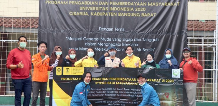
As an effort to find clean water sources in the Cisarua area - West Java, the Faculty of Mathematics and Natural Sciences, University of Indonesia (FMIPA UI) through the Community Service and Empowerment Team (PPM) chaired by Dr. Tito Latif Indra, S.Si., M.Si. conducted a survey and measurement using the ground penetrating radar (GPR) method at the Bina Siswa Dormitory of SMA Plus Cisarua, West Java.
This activity is part of the community service and empowerment program (pengmas) carried out by FMIPA UI academics to find solutions to the difficulties in obtaining clean water experienced by local communities.
"Based on the interpretation of the results of the GPR method by the 2020 UI PPM team, we obtained a groundwater aquifer zone around the Bina Siswa Dormitory of SMA Plus Cisarua at a depth of 15-20 meters. The results of our interpretation, the groundwater aquifer zone is at a depth of 15-20 meters. The hope is that after getting these results, well drilling will be carried out immediately so that there is no need to buy clean water anymore to meet the daily needs of residents around the dormitory," said Tito conveying the results of the survey conducted by his team.
On the same occasion, Iskandarsyah, M.Sc., a lecturer in the UI Geophysics Undergraduate Program said that West Bandung Regency, especially Cisarua District, is geologically composed of volcanic rock lithology and sandy tuff which are not very good as groundwater aquifers so that in several locations the community has difficulty obtaining clean water. Rainwater that falls to the surface can actually be accommodated in groundwater reservoirs, but because the lithology of the rocks is dominated by volcanic rocks, it is possible that the water will not be accommodated and will immediately enter deeper rock layers.
"There is a possibility that the groundwater aquifer layer in Cisarua is typical of deep groundwater, so it is necessary to use geophysical methods to find the groundwater aquifer zone," said Iskandarsyah.
GPR is a geophysical method that utilizes radar waves (EM waves with a frequency of 10 - 1000 MHz) into the earth to map conditions below the surface. The mapping event occurs when the GPR transmitter emits EM waves into the earth from the surface. This method is widely used in searching for groundwater aquifer zones in several countries such as Japan, Australia, and Morocco. The implementation of the GPR method survey and measurement took place on October 19-21, 2020. "We hope that with the presence of our team in the field, we can directly answer the needs of the local community and help create a more decent life," said Dr. Tito.
Post Views: 136
Share this:
Facebook
X
LinkedIn
WhatsApp
Email
Tumblr
Telegram
Print
Other News